Mildmay Liveable Neighbourhood
Find out what we aim to achieve for the Mildmay Liveable Neighbourhood, see our designs that we have consulted on, and next steps for the project.
As part of our efforts to create a greener, healthier borough we are introducing a liveable neighbourhood in Mildmay.
In October 2024, the council announced the implementation of the Mildmay Liveable Neighbourhood (LN).
Since November 2024, the council has been constructing a series of improvements within the project area, including new and improved public spaces, new and improved pedestrian crossings and pavements, new cycling infrastructure, and new roadside green space. The first batch of traffic filtering measures as part of the project were introduced from Monday 27 October 2025.
We announced the funding for this project in 2020, but it was delayed because of the Covid pandemic. Since then, we've listened to your feedback over two rounds of engagement. Based on what you told us, we created final designs for the neighbourhood and held a public consultation on these designs in September and October 2023.
Traffic filters active since Monday 27 October 2025
Traffic filters are fixed points on local streets, which most motor vehicles are not permitted to drive through. Drivers can still reach all addresses that are currently accessible by motor vehicles but might need to take different routes to some of them.
The first traffic filtering measures as part of the Mildmay Liveable Neighbourhood project will be introduced from Monday 27 October 2025.
These traffic filters are located at the east end of Mildmay Road, at the east end of St Jude Street, and on King Henry’s Walk adjacent to the Adventure Playground.
Find out more about the planned traffic filters in the Mildmay LN area on Let's Talk Islington.
The council also operates several traffic filters in other areas of the borough. The traffic filters in the Mildmay Liveable Neighbourhood project area operate in the same way as those already in place elsewhere in Islington.
We will keep residents updated as the project continues and let you know if construction will affect you. We will do our best to reduce any disruption.
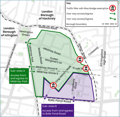
Alt text: Map showing the locations of the new traffic filters in the Mildmay LN area, and how to access each area either side of the traffic filters by motor vehicle.
Caption: Map showing how to access different parts of the project area by motor vehicle from Monday 27 October 2025.
With the traffic filters in place, all addresses that could be reached by motor vehicle before the traffic filters were implemented are still able to be reached by vehicle today. However, you may now have to take a different route to reach that address.
Once the traffic filters are in place, addresses on the following roads would be accessed by motor vehicle via Mildmay Park only. These roads fall within “sub-area A” in the map above:
- Mildmay Grove South
- Mildmay Grove North
- Wolsey Road
- Queen Margaret’s Grove
- King Henry’s Walk (north of the King Henry’s Walk Adventure Playground)
- St Jude Street
- Kingsbury Road north of the railway bridge
- Mildmay Road (west of the existing width restriction, close to the junction with Boleyn Road)
- Woodville Road, Elton Place, and King Henry Street
Addresses on the following roads would be accessed via Balls Pond Road only. These roads fall within “sub-area B” in the map above:
- King Henry’s Walk (south of the King Henry’s Walk Adventure Playground)
- Kingsbury Road south of the railway bridge (no change from the current situation)
Numbers 1, 3 and 5 Mildmay Road would be accessed by motor vehicle via Crossway from the A10, or alternatively from Newington Green via Matthias Road and Boleyn Road.
Similarly, access by vehicle to all addresses on Matthias Road, Boleyn Road, Pellerin Road, Crossway and John Campbell Road, Gillett Street / Gillet Square, Bradbury Street, Kingsland Green and Kingsland Passage will be via Crossway from the A10 or alternatively from Newington Green via Matthias Road and Boleyn Road.
About the Mildmay Liveable neighbourhood
The liveable neighbourhood will create pleasant and lively streets, where communities can come together to spend time with their neighbours, support local shops and children can play and travel safely. With more greening including plants and trees, seating for neighbours, and reduced traffic volumes, the liveable neighbourhood will transform Mildmay’s streets.

How we have engaged with and consulted you
Since 2021, we have worked with residents and businesses to develop proposals for the Mildmay Liveable Neighbourhood based on what improvements you wanted. In autumn 2023, we held a public consultation on our final draft proposals.
Engagement timeline
| Date | Phase | Description |
|---|---|---|
| Autumn 2022 | 1 - Early engagement | Listen to local people's views on where and how you think we should improve streets and public spaces in the Mildmay project area |
| Winter to spring 2023 | 2 - First designs | Get more local feedback on the first proposals for the liveable neighbourhood. |
| Autumn 2023 | 3 - Public consultation | A formal public consultation on the final draft designs |
Our public consultation
We ran a public consultation on final draft proposals for the Mildmay Liveable Neighbourhood between Monday 11 September and Sunday 8 October 2023.
Most people who responded to our consultation survey agreed that the plans would be positive for the area, as well as their health and wellbeing. There were also some concerns raised about some elements of the project.
You can find out more about the proposals at the consultation and an independent report on the results on our project consultation webpage.
For more information
- Read our frequently asked questions on our project page for answers to popular specific queries that residents have asked us about the scheme.
- For general information and questions about liveable neighbourhoods in Islington, you can visit our main people-friendly streets FAQs page.
- If you have any questions that are not answered here or other links on this page, contact us at Mildmay.LiveableNeighbourhood@islington.gov.uk.
Useful documents
-
Mildmay LN Officer Key Decision Report October 2024

(pdf, 300 KB)
-
Mildmay LN OKDR Appendix 1 Scheme map and proposals
(pdf, 419 KB)
-
Mildmay LN OKDR Appendix 2 Codesign and engagement summary
(pdf, 2 MB)
-
Mildmay LN OKDR Appendix 3 Consultation report
(pdf, 1 MB)
-
Mildmay LN OKDR Appendix 4 Responses to issues raised
(pdf, 229 KB)
-
Mildmay LN OKDR Appendix 5 Equalities Impact Assessment
(pdf, 516 KB)
-
Mildmay Ward Partnership minutes 06 Oct 2022
(pdf, 207 KB)
-
Mildmay Ward Partnership presentation 06 Oct 2022
(pdf, 7 MB)
-
Mildmay Ward Partnership minutes 20 July 2022
(pdf, 188 KB)
-
Mildmay Ward Partnership presentation 20 July 2022
(pdf, 2 MB)